Click on the individual features or maps to customise your view. Select or deselect all if needed.
Lorem ipsum dolor sit amet. Qui labore dolores qui dolores aperiam aut nihil tenetur qui cumque ipsa qui possimus neque et tenetur velit eos quisquam expedita. Et maxime voluptatum eum laudantium officiis eos nihil quae et sint inventore qui voluptatum consequatur? Sed consequuntur quia non accusamus perspiciatis qui deserunt porro.
At dolor distinctio aut omnis beatae ut numquam omnis qui voluptatem iure. Sit minus similique eum internos modi a velit eaque et fugiat aliquid ut iste quia qui accusantium tempora in harum sunt. Non repellat consequatur qui nostrum excepturi et earum error. Qui obcaecati dolor in quae voluptas quo voluptas distinctio sit delectus assumenda non sint autem.
Ut voluptatem quae qui reprehenderit rerum eos numquam saepe sit exercitationem animi sit repellat dicta. Ut error voluptatem qui eveniet quibusdam eos unde assumenda aut dolor accusantium est iure aliquam eos eligendi expedita aut minima voluptatem.
Introduction
Maps of early America do not tell the whole truth. While they frequently include scales and lines of latitude, their aim was not geographical accuracy. For the British – the makers of the bulk of the maps used here – the aim was to demonstrate actual and claimed possession of territory in North-eastern North America. In the process, mapmakers captured information that reveals some of the deeper dynamics of the natural and human spaces of the known Continent. In this map, we seek to bring these stories to life by illustrating the common worlds of early America.
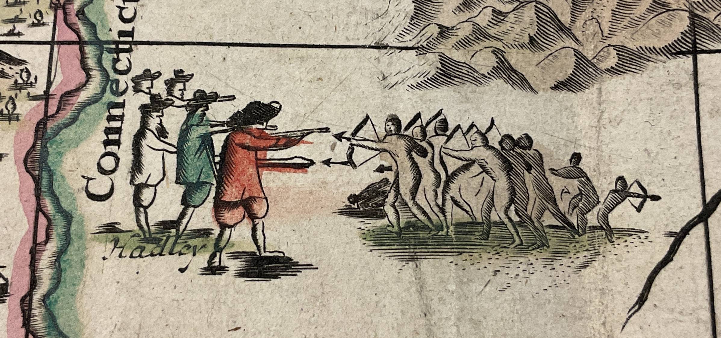
Settlement was fragmented and confined to a narrow strip of the Atlantic coast. Indigenous peoples are a constant presence in British maps. When mapmakers portrayed colonial possessions, they were in fact drawing a coastal, interior, and Continental landscape of Indigenous nations, who remained in control of the majority of North American land and resources in 1780. While they drew colourful boundaries around British colonies and placed English names over wide expanses of paper and territory, settlement was fragmented, small scale, and confined to a narrow strip of the Atlantic coast. Given the relative imbalance of power, colonists used violence to defend claims to land, and war with neighbouring Indigenous nations was endemic. However, this does not mean that the Northeast was defined by two separate and warring worlds.
A world connected by diplomacy, alliance and movement.
While the common worlds of Indigenous and British peoples were occasionally pushed apart by violence, they were also drawn together by pathways of connection, movement, diplomacy, alliance, and exchange. This model of inter-cultural relationship has been called a ‘middle ground’, and it existed in tension with a colonial impulse to establish and defend hard borders and boundaries, lines that excluded ‘outsiders’.
Homelands
1. Homelands
American history begins with the deep history of the land and its peoples as they existed long before the arrival of Europeans. British explorers were often professional soldiers who made coastal landings and moved up the dozens of rivers that led inland. They claimed possession of these spaces according to legal arguments that gave ownership of empty land to whoever occupied and ‘improved’ it. But they soon learned that the land was not empty. The Indigenous name of the place they called ‘Virginia’ is Tsenacommacah: the densely inhabited land.
The Indigenous landscape was more than a homeland: it was a site of creation. For the coastal Algonquian it was the Dawnland, for the Haudenosaunee it was Turtle Island – the place where everything had its beginning and its being. The land was a cultural and moral space, infused with fundamental beliefs, and overlayered with stories that were enacted, remembered, and shared among kin and with Europeans.
The sacred ties between land and people were recited in the Ohén:ton Karihwatéhkwen, the ‘words that come before all else’ that give thanks to the earth, waters, animals, plants, winds, the sun and stars. The maps shown here contained this environment, and the words of this address were an account of the relationship between peoples and the ecosystems that supported them.
Our Ancestors came out of this very Ground, and their Children have remained here ever since.
The land was political. Haudenosaunee oral tradition drew the land and its history together in multiple versions of the story of the formation of the Great League of Peace, and where Deganawidah taught Hiawatha the rituals of the condolence ceremony. As the Onondaga diplomat Canasatego declared at a treaty council in 1744, ‘our Ancestors came out of this very Ground, and their Children have remained here ever since’.
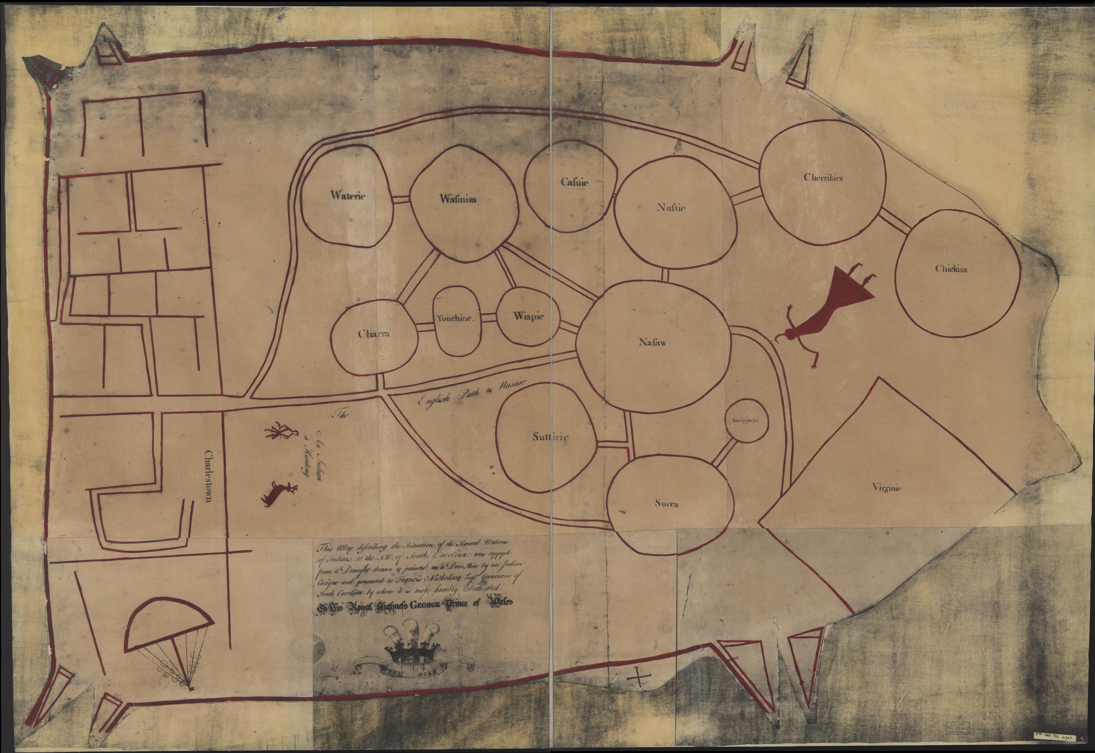
Indigenous peoples were map-makers, but these maps were carried in the mind and then sketched with charcoal on hide or bark, or drawn with a stick in soft soil or the ashes of a fire. Colonial officials copied these maps, which allow us to glimpse the ways in which Indigenous nations saw themselves in relation to other peoples. The famous Catawba deerskin map portrayed two contrasting ways of being on the land: the villages and towns of the Catawba are represented as a network of circles connected by paths, while the British colonial city of Charlestown is shown as a grid system of streets. The relative size of circles (a sacred shape in Indigenous culture) denotes the importance and power of each nation; the paths linking them represent connections of kinship, trade and alliance.
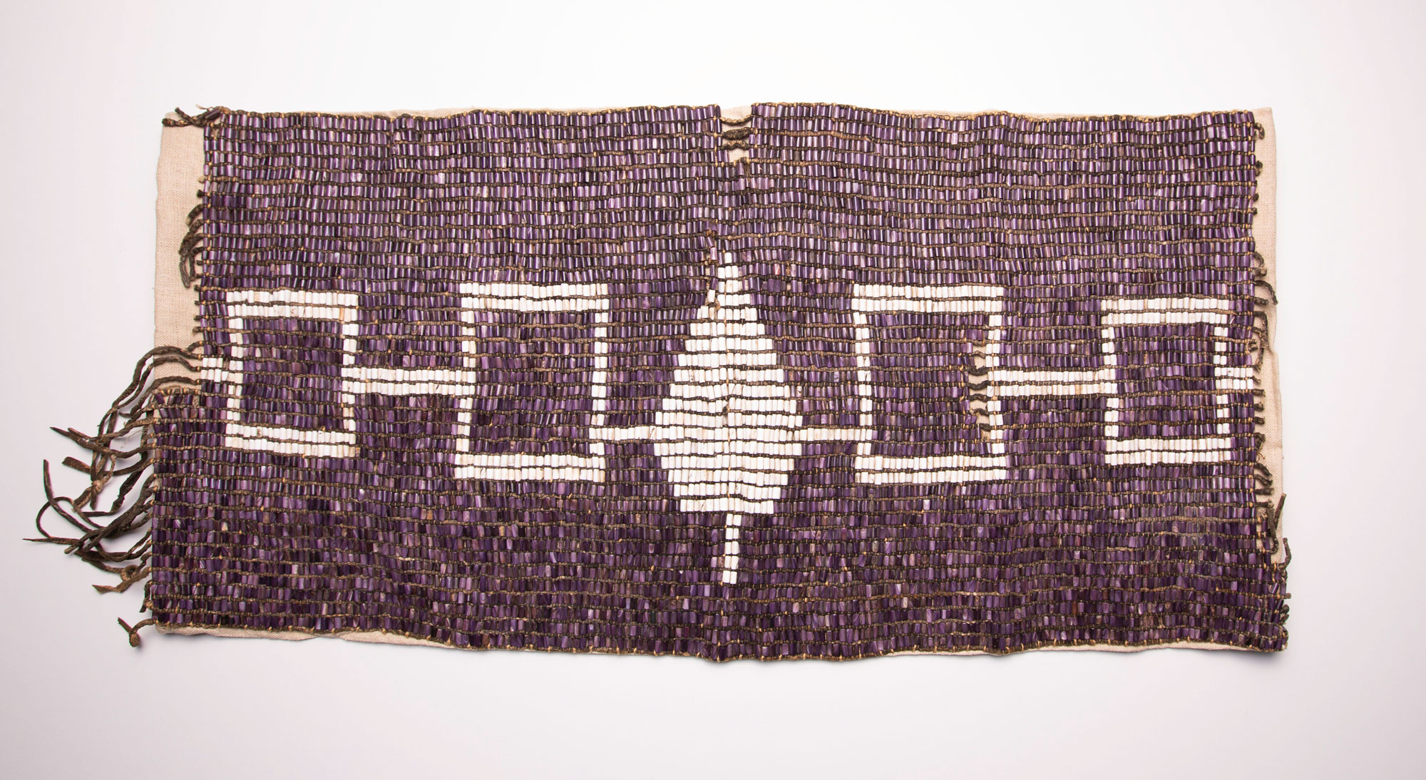
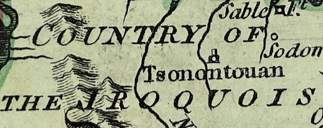
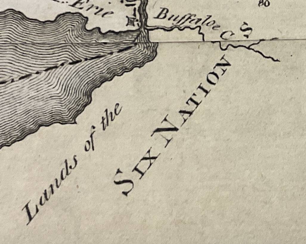
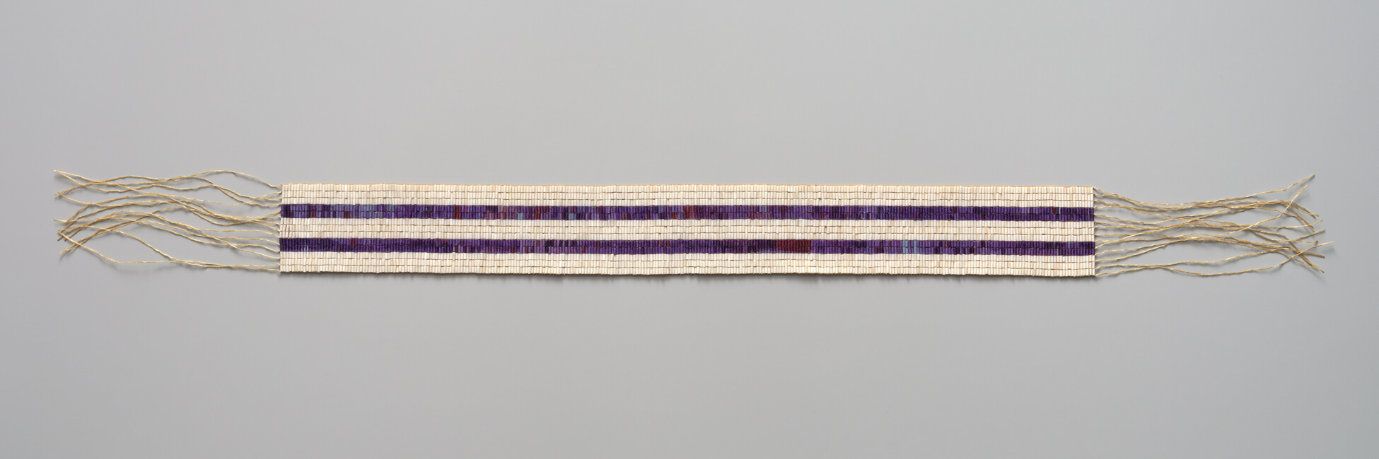
Haudenosaunee can be translated as the ‘whole house’, and their landsin what is now New York state were conceived as a metaphorical Longhouse with ‘doors’ facing east and west. The Seneca guarded the western door and the Mohawk the eastern one that faced toward the British colonies. Between them were the Cayuga, Onondaga and the Oneida. The longhouse and its nations are represented on the Hiawatha Belt that shows the nations of the Confederacy gathered under the Great Law. The central image of a white pine symbolises the tree of peace around which the nations shelter, and the location of the central council fire at Onondaga.
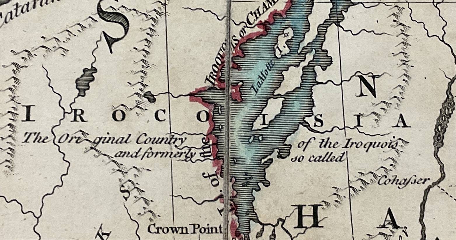
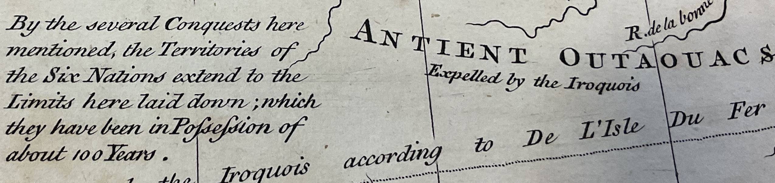
British mapmakers took care in noting the positions of each nation and territorial extent of the Confederacy as a whole. In John Mitchell’s map of the British and French territories in North America, the label ‘Six Nations or Iroquois’ cuts across Virginia, Pennsylvania, New York, and north of the Great Lakes. Mitchell also identified the Haudenosaunee’s much smaller original homeland Irocoisia, centred on Lake Champlain.
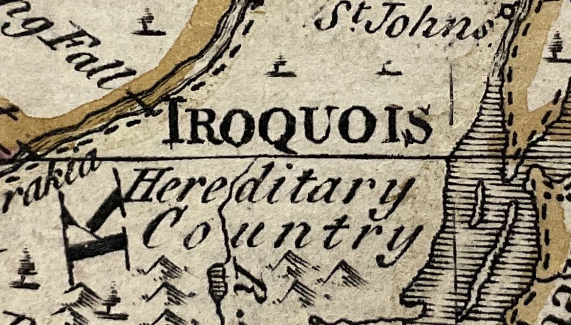
Yet this was not a wholly peaceful landscape. In response to the effects of European soldiers, traders and settlers the Haudenosaunee carried out campaigns against neighbouring nations, seeking captives and access to new hunting lands. In 1657, a missionary observed that the villages and towns of the Five Nations contained ‘more foreigners than natives of the country’. For the British, the Haudenosaunee were like themselves: an expanding commercial and military power that brought other nations under their control and, as allies of the Crown, into Britain’s imperial network. This myth of ‘Iroquois empire’ was used by the British to bolster their own power in interior spaces where Indigenous nations were fully sovereign.
The United Colonies emerged as a new power in 1775 and sought diplomatic relations with the Haudenosaunee. However, the peoples of the longhouse divided over the conflict between Britain and her colonies: the Mohawk, Seneca, Onondaga, and the Cayuga remained allied to the Crown via the Covenant Chain. In 1779, George Washington planned a massive military operation ‘directed against the hostile tribes of the six nations of Indians, with their associates and adherents’. He continued that it was necessary to complete ‘the total destruction and devastation of their settlements’. Washington’s campaign was not a simple war of conquest, but a carefully planned engagement against nations who matched the United States’ political and military power.
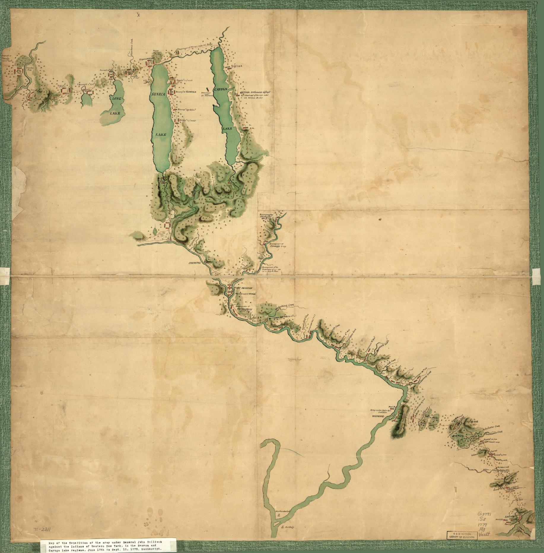
The village worlds of the Haudenosaunee were broken apart. Thousands fled to the British stronghold at Fort Niagara, and the nations as whole experienced famine and displacement, their lands seized by the United States by the Treaty of Fort Stanwix (1784). But the Six Nations did not vanish. Early American maps positioned them on the western edges of expanded colonial spaces, not in reserved lands but in homelands that remain within the borders of New York state.
Pathways connections between places and peoples
Pathways were connections between places and peoples.
For the Haudenosaunee, the path was a powerful metaphor. It represented a connection between peoples, and defined the purposes of movement – hunting, trading, travelling to a diplomatic council or going to war. Where a diplomatic relationship was in good health, the path was described as ‘clear’ and ‘open’; and where that relationship had lapsed or been marred by conflict, the path was described as ‘grown over’, which required a diplomatic council to ‘sweep the path clean’. Paths were not interchangeable: peace and war paths were kept separate. According to the diplomat Conrad Weiser, there was ‘the usual Road that ambassadors travel’. The Haudenosaunee represented paths on wampum belts. The two- row belt (Gä•sweñta in Onondaga) used two strips of purple beads on a white ground to represent the parallel paths of the Haudenosaunee and the European peoples who settled among them. Friendship belts connected two figures with a pathway between them, symbolising free movement and open communication. Diplomatic councils began with the greeting at the Edge of the Woods and the ritual cleansing of travellers, including the removal of briars and thorns that were picked up on paths leading to the council.
Pathways were conduits of communication, which were vital to the British as they sought to win and retain Indigenous allies against the French. William Johnson, the Crown’s superintendent of Northern Affairs, operated from locations in the Mohawk Valley, and was skilled at using Haudenosaunee networks as ways of gathering, assessing and sharing vital political information. At a conference with the Mohawk in 1753, he stressed the importance of moving news along networks without altering key details:
I must remind you of a new Custom lately introduced, very inconvenient for our mutual interest, that is, when you receive news from the Westward Southward or any other quarter, you send it from one Castle to another, till it arrives quite altered from what it was at first. I therefore require you by this Belt of Wampum to follow the old custom & send it as far as you intend it should go directly by some of your own Nation.
Addressing the Seneca, Johnson used the metaphor of the longhouse as an integrated pathway across long distances, and facing in several directions in order to stress the importance of swift pathways of communication:
As you have always been looked upon as the door of the Six Nations where all news, especially from the Westward and Southward must enter and go out, we don’t hear this door open as we used to do formerly, and believe it to be worn out, & think it necessary to hang on a new one of such wood as will never decay; the noise of which when it opens should alarm all the Confederacy.
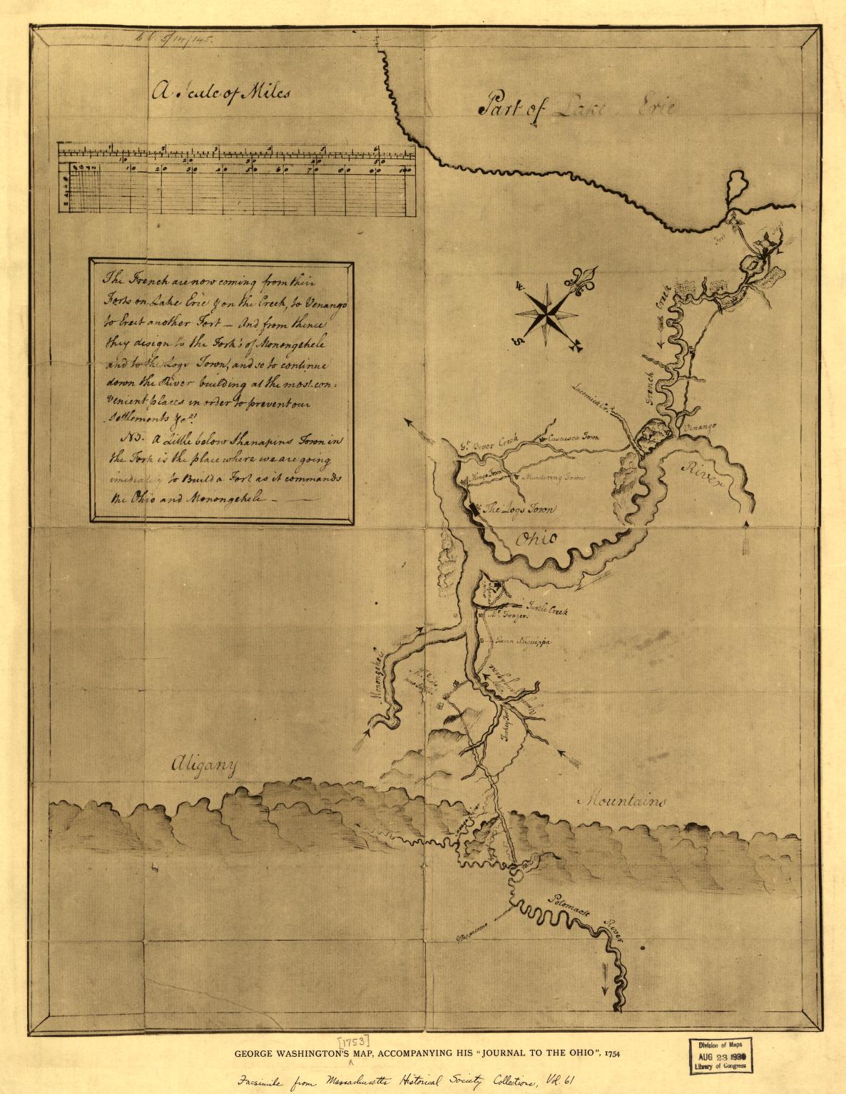
For the geographer Lewis Evans, the Northeast was an ‘ocean of woods’. As a twenty-one-year-old officer, George Washington experienced the difficulties of movement as he carried out a mission to deliver an official dispatch to French commanders, telling them that the British Crown had exclusive right to territories in the Ohio country. Washington understood that travel required Indigenous permission and assistance. Along the way, he dispatched gifts, a ‘String of Wampum, and a Twist of Tobacco’ ahead by runner to the Six Nations. To find his route, he consulted Tanaghrisson, a Catawba adopted by the Seneca who served as an emissary between the Haudenosaunee and the nations of the Ohio. Washington ‘desire’d him to relate some of the Particulars of his Journey to the French Commandant, and Reception there; and to give me an Account of the Ways and Distance’. He received an account of speeches between the French and the Delaware nation of the Ohio, words that were represented on a ‘very large String of black and white Wampum, which was to be sent up immediately to the Six Nations’.
Washington found himself serving as a messenger between the Ohio nations and the Haudenosaunee, carrying wampum, news, and gifts in addition to his original dispatch. His party struggled to make progress toward the French positions, having chosen to set out at the end of October.
At 11 o’Clock we set out for the Fort, and were prevented from arriving there ‘til the 11th by excessive Rains, Snows, and bad Travelling, through many Mires and Swamps, which were obliged to pass, to avoid crossing the Creek, which was impossible, either by fording or rafting, the Water was so high and rapid.
Finding open water, Washington decided to try travel by canoe:
We had a tedious and very fatiguing Passage down the Creek, several Times we had like to have been staved against Rocks, and many Times were obliged all Hands to get out and remain in the Water Half an Hour or more, getting over the Shoals; at one Place the Ice had lodged and made it impassable by Water; therefore we were obliged to carry our Canoe across a Neck of Land.
Washington eventually abandoned his bulky British uniform, and ‘put myself in an Indian walking Dress’. Transposed onto John Mitchell’s map, Washington’s journey could be measured in inches. In this short distance, he was never in ‘British’ or French territory, but instead moved through unseen diplomatic and kinship pathways that carried wampum, information and gifts of tribute along multiple connecting routes.
As Washington learned, rivers were the highways of early America. Contemporary maps, such as the one based on Joshua Fry and Peter Jefferson’s detailed survey of Virginia, emphasised rivers as conduits of communication and movement. This was a matter of imperial policy. According to a memo prepared for George III, ‘no Communication can be depended on in that Country which is not by Rivers or Lakes where we can command the Navigation’. Just as prominent were ranges of the Northeast Appalachians that formed a natural barrier to the west, and could only be crossed at a small number of places.
Europeans found their way along single file Indigenous pathways. Movement, rather than rootedness in one location, was a key expression of power. The Northeast was animated and alive with multiple forms of connection, from kinscapes, trade paths, war paths (or ‘force roads’) and traditional routes to council fires and key locales in the diplomatic landscape. The difficulty of travelling over distance meant that rivers and lakes were the principal conduits of connection, and contemporary maps give prominence to these. At the same time, the assumptions that underpinned a world conceived as paths clashed with concepts of borders as boundaries that could not be easily crossed.
Villagers, Settlers
European claims to the conquest of the ‘new world’ were primarily intellectual, based on ideas of political, cultural, racial and technological superiority. English writers debated how colonies should be ruled, but there was a deeper question of how they were ‘rightfully’ obtained. The law of nations, the precursor to modern international law, stipulated that powers could obtain lands outside their borders by means of conquest and occupation. According to the Swiss writer Emer de Vattel, ‘When a nation takes possession of a distant country, and settles a colony there’ then this territory ‘naturally becomes part of the state, equally with its ancient possessions’.
The experience of colonisation shaped British claims to the possession of territory. Writers on colonial affairs based the rightful possession of colonies on the argument that warfare with Indigenous sovereigns was the basis of ‘rightful’ conquest. Following wars between the Powhatan Confederacy and colonists in Virginia, Edward Waterhouse, secretary of the Virginia Company, stated the case for the annexation of Indigenous territory by war: ‘So that we, who have hitherto have had possession of no more ground then their waste . . . may now by right of Warre, and law of Nations, invade the Country, and destroy them who fought to destroy us: whereby we shall enjoy their cultivated places [which] shall now also be possessed entirely by us’. Over one hundred years later, William Blackstone recalled this and other conflicts and identified them as the basis of Britain’s territorial empire in North America. ‘Our American plantations [were] obtained in the last century either by a right of conquest or driving out the natives (with what natural justice I shall not at present enquire) or by treaties’.
The English settled among Indigenous nations.
The English settled among Indigenous nations and were drawn into networks of trade and diplomacy – they entered these circuits of power as minor players, far fewer in number and faced with challenges of basic survival. Weakness, rather than strength, shaped their interactions with Indigenous nations. The maps that they produced sought to portray mastery of the landscape, but they also depicted Indigenous peoples as actors, living on and in the land and seemingly untroubled by the presence of the English.
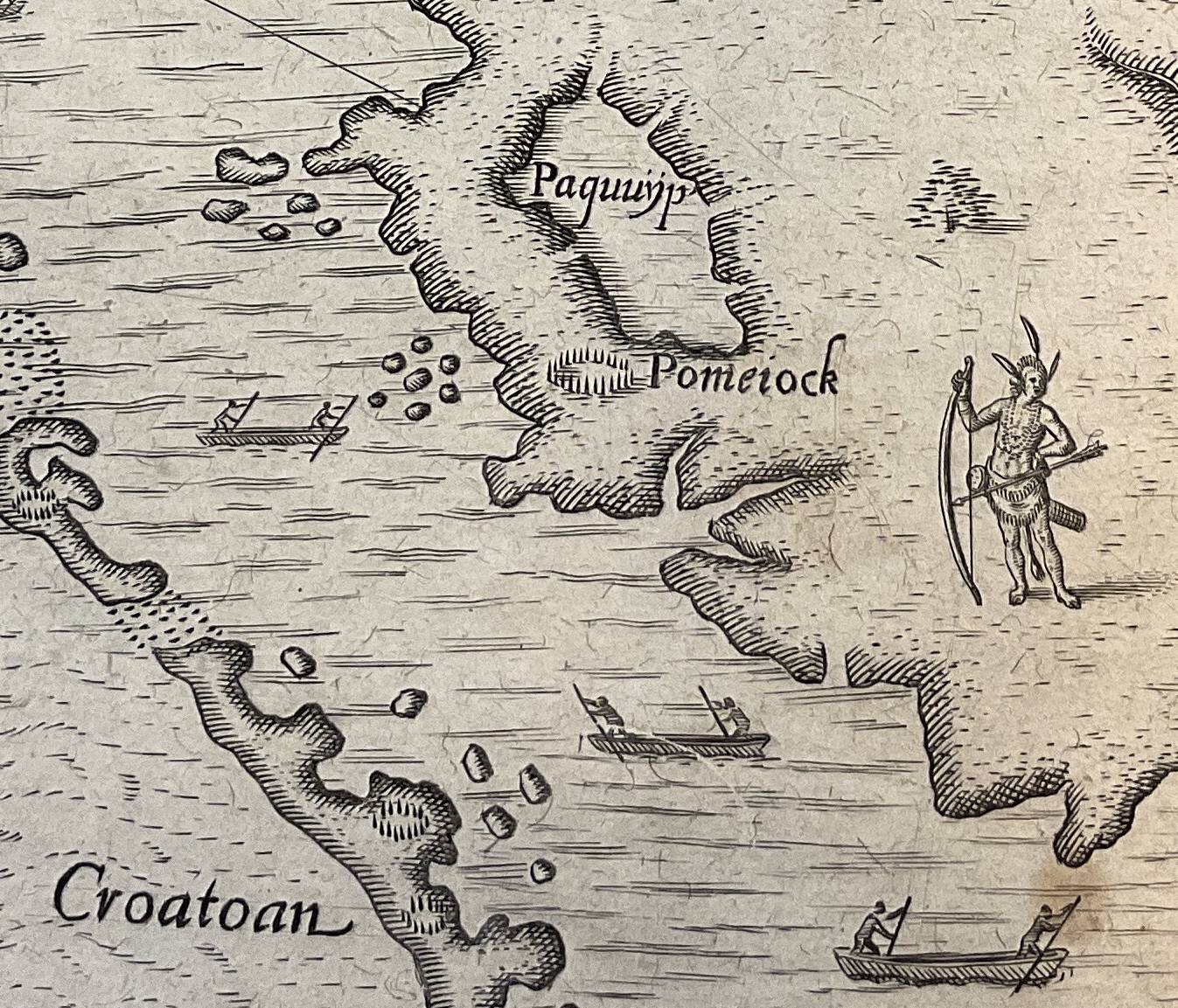
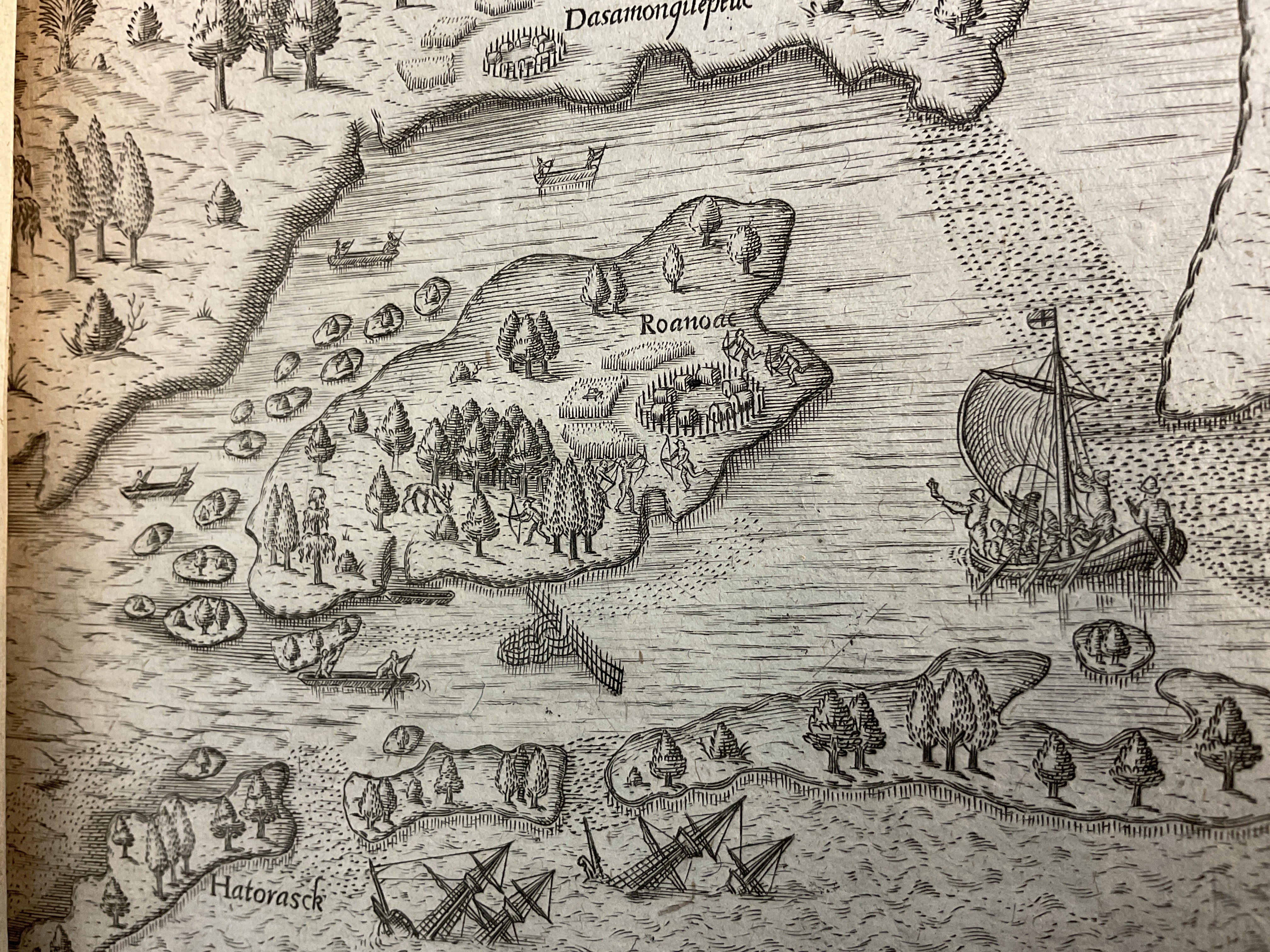
John White’s America Pars (1590) of Virginia employs a symbolic language to denote English power and the potential for mastery of the landscape. The first is the label of Virginia ‘now called for the first time in English’, that is superimposed on a map that, with one exception, contains exclusively Indigenous places. Each settlement is positioned and represented by a name and the figure of a palisade. White’s map also depicted English technological mastery and military supremacy, showing coasts lined with eight English ships that dwarf the four dugout canoes of the Powhatan.
A century after the creation of White’s map, English settlements in ‘New England’ extended inland as far as the Hudson River. Colonists found themselves in small enclaves surrounded by large and coherent Indigenous social formations. Rather than a separation and peoples and cultures, this region is characterised by proximity and intermingling: colonists would have seen Indigenous peoples daily, and this close connection amplified violence when it happened. Colonial governments sought to regulate the affairs of what they called ‘our Indians’, who lived within the ‘jurisdiction’ of colonial governments. In Virginia and New England, legislatures passed dozens of laws that restricted the political and cultural freedoms of Indigenous peoples. These measures led to widespread conflict in Virginia and New England. John Foster’s map of New England (1677) showed colonial towns in a landscape with only a handful of Indigenous placenames, creating the impression of a retreating Indigenous village world.
The Haudenosaunee were also settlers.
The creation of new colonies disrupted the flows of Indigenous politics. Pennsylvania was established in 1681, and its presence broke the pattern of relations between the Delaware, Susquehannock and the Haudenosaunee. They found themselves at war with rival groups and caught up in the power struggle between colonies for control of trade and territory. One Mohawk speaker appealed to the Governor of New York in 1687: ‘Where can we run? There is a great crowd of Indians who would pursue us everywhere anyway’.
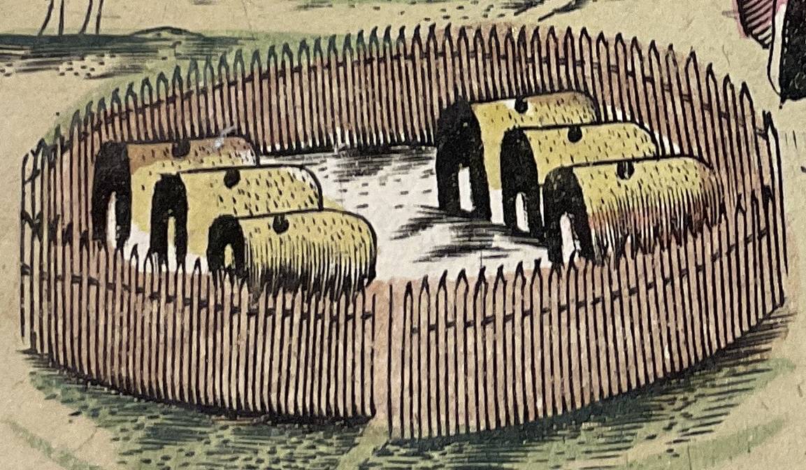
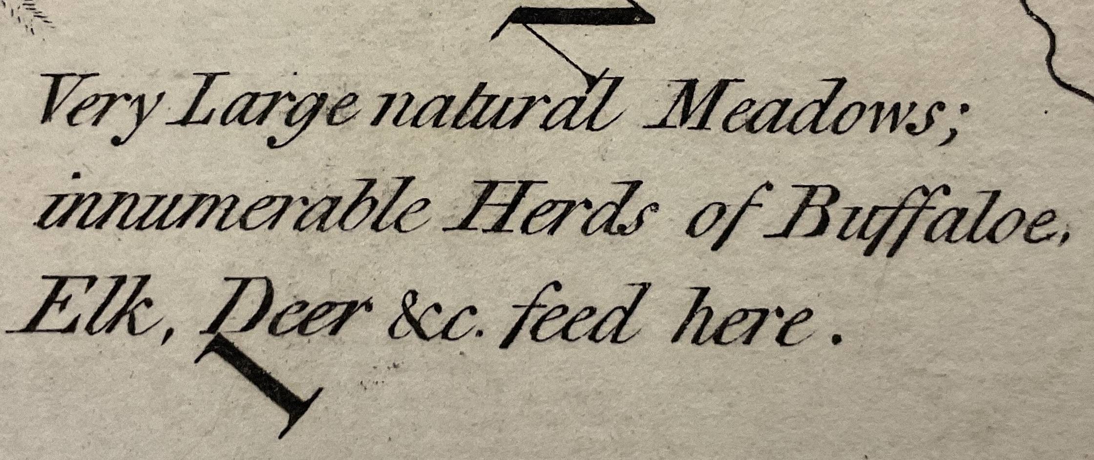
The Haudenosaunee moved villages every twelve years and chose locations that were both strategic and rich in resources: river valleys for settlement, uplands, and forests for hunting; these were managed by seasonal burning to clear undergrowth in order to create optimal habitats for large animals. All of this was happening far from the sight and experience of eastern colonies.
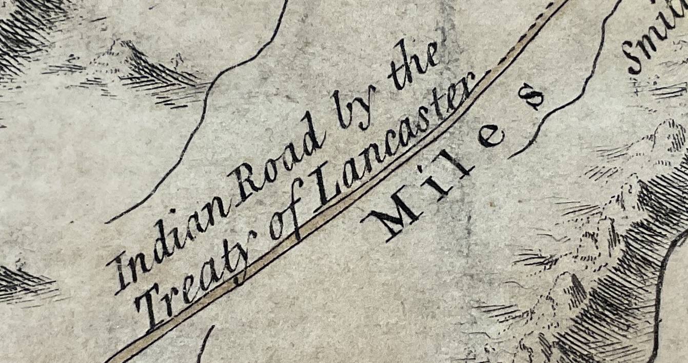
Settlers pushed out of towns and villages into the ‘back country’. Maps began to carry text blocks that identified the location of the best land, and left blank spaces for the formation of new colonies. Lewis Evans’ map of the western reaches of the middle colonies declared that, ‘This Country is finely improved to the Mountains; and the Inhabitants enjoying the Fruits of the Difficulty of first Settling. The Roads are very well accommodated’. Evans noted that ‘the Woods being yet so thick’ it was difficult to ‘fill those Parts where our Settlements and Discoveries have not yet extended to’. But Evans’ map did not erase Indigenous nations or their settlements. At the top centre of the map is Onondaga, ‘where the Gen. Council of the Confederate Republic of the Six Nations meets’. Anglophone settlement was confined to a belt that lay to the south of Haudenosaunee territory, which is bordered by the Blue Mountains and the upper reaches of the Delaware River.
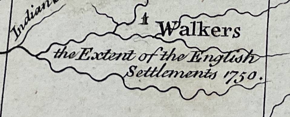
As British traders, diplomats and settlers journeyed further west, mapmakers began to illustrate a ‘frontier’. Herman Moll’s map of the Crown’s ‘dominions’ offered a glimpse of the Continental interior, with settlements confined to the Atlantic coast and river valleys. Similarly, John Mitchell showed the western borders of colonies reaching toward the Mississippi and noted the ‘extent’ of English settlement in 1750 – which reached what is now Harlan County, Kentucky.
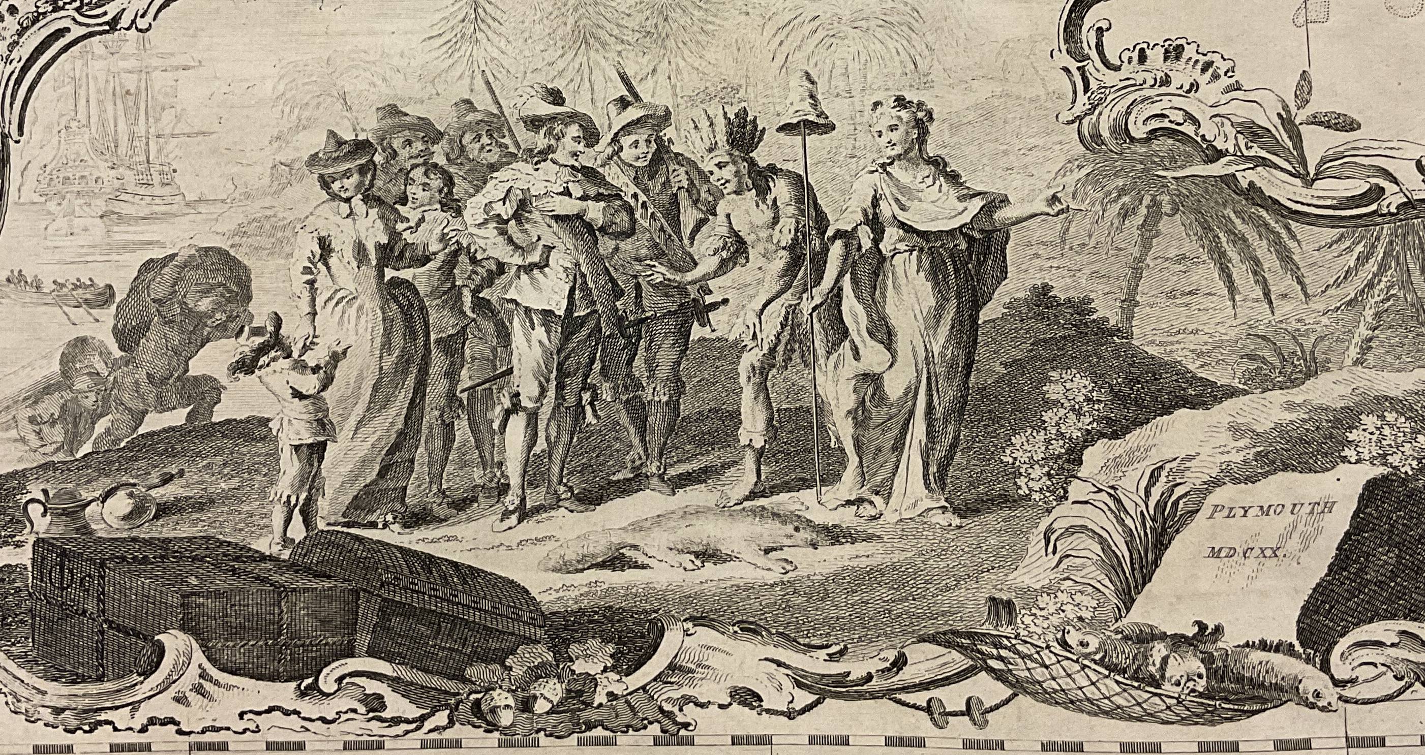
Increasingly, maps portrayed colonies as parts of a larger British empire, while colonial officials proposed that they were increasingly independent from the Crown. Speaking before parliament in 1766, and recalling the Seven Years War, Benjamin Franklin noted the autonomy of colonies within the British empire: ‘They defended themselves, when they were but a handful, and the Indians much more numerous. The continually gained ground, and have driven the Indians over the mountains, without any assistance from this country’. In Franklin’s view, colonists were themselves the main drivers of Britain’s imperial expansion. Where maps of the seventeenth century marked colonial towns that had been cleared by Indigenous war parties, a century later this once contested ground was consolidated into neatly bordered colonies (on the verge of becoming states). Thomas Jeffries’ map of the ‘inhabited’ parts of New England included an illustration of the landing of the ‘Pilgrims’ at Plymouth in 1620, who were welcomed ashore by Liberty and an Indigenous sachem. Images like this formed the basis of a claim that the British acquired Indigenous territory peacefully, and were intended to mask the reality of inter-cultural violence.
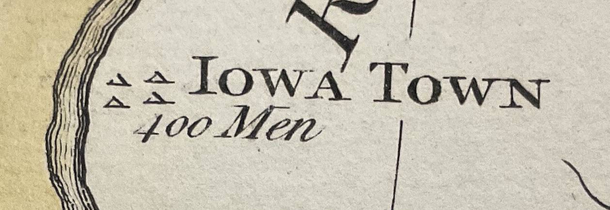
Jefferies’ map is concerned with larger spaces, counties and townships that are based on ‘actual surveys’ and refined by scientific observation. Beyond these lines, there is a ‘west’, designated as ‘Part of New York’. This western region also appears at the centre of Thomas Hutchins’ 1778 map of the ‘western parts’ of the middle colonies, showing embryo states – Indiana and the Illinois Country, and offering commentary on the quality of land. On the western edge of the map, Indigenous towns are noted, each with its number of ready warriors.
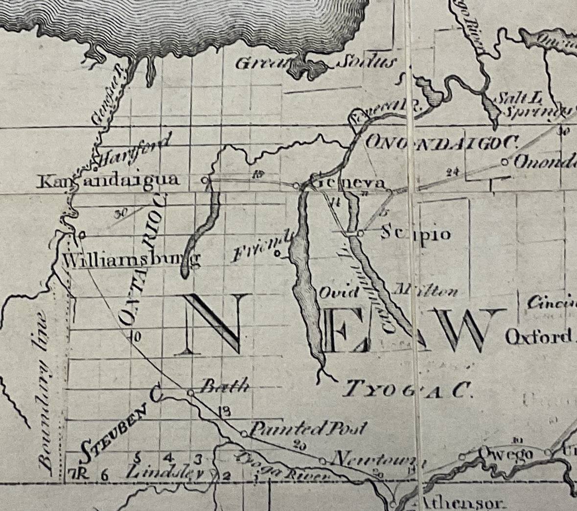
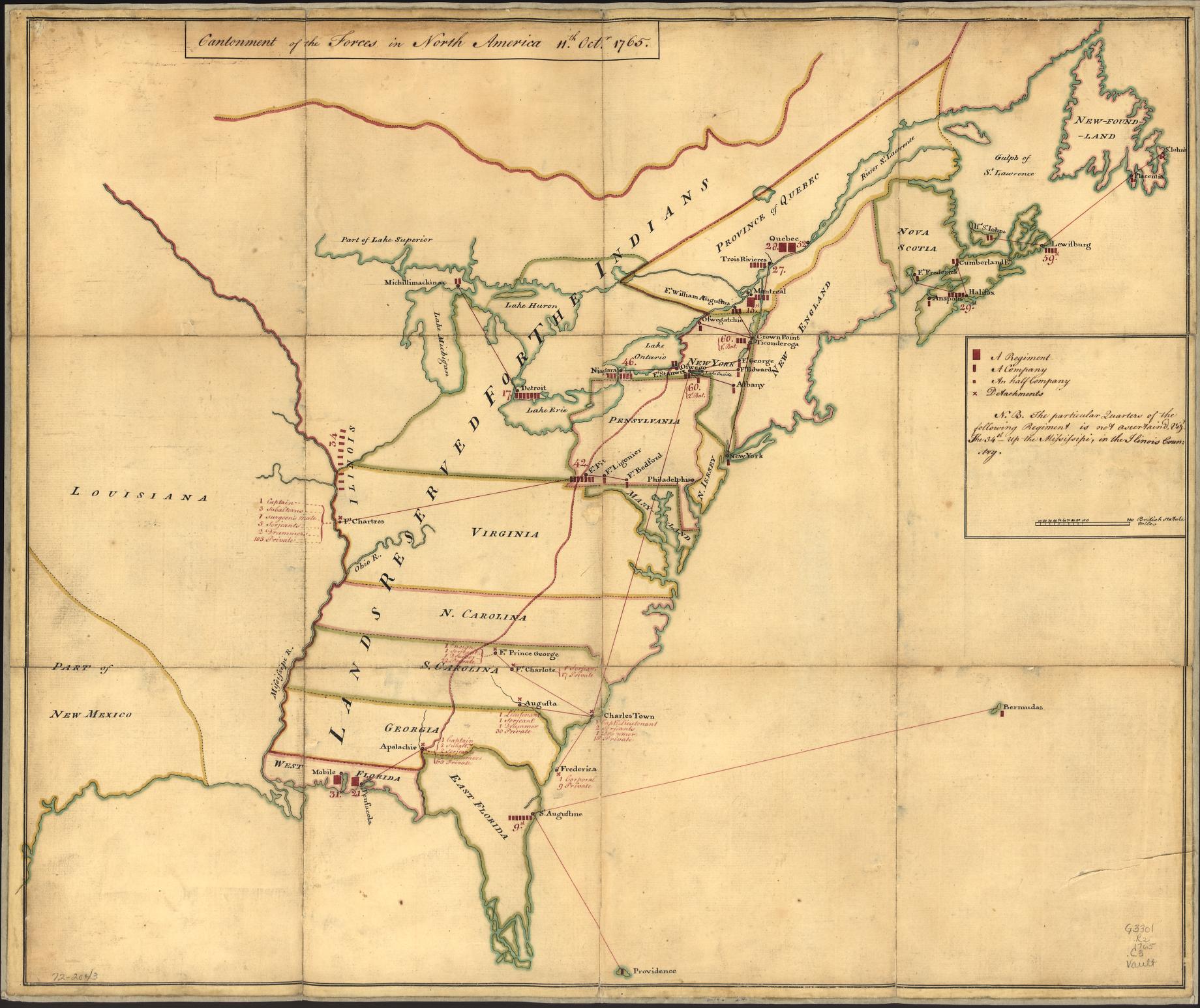
Abraham Bradley’s A Map of the United States shows territorial consolidation on an even larger scale, but the layering of landscapes is still present. The central council fire of Onondaga is clearly positioned above Canandaigua, Seneca and Cayuga Lakes. Yet this historically important centre of the Longhouse is shown captured within a neat range of townships and surrounded by place names drawn from classical and Anglophone sources. Bradley’s map presented a landscape being transformed by the creation of ordered lines of property, the extension of the jurisdiction of American government, the emergence of a new infrastructure of communication in the form of post roads.
Bradley’s map shows state-driven colonialism that created the conditions for the free movement of settlers, and to constrain the movement of Native peoples. As John Adams noted in remarks on the basis of American power: ‘If you make enquiry into the circumstances of the different parts of America, at this day; you find the people in all the States pushing their settlements out into the wilderness, upon the frontiers, cutting down the woods, and subduing new lands, with as much eagerness and rapidity, as they used to do in former times of war or peace’.
Lines
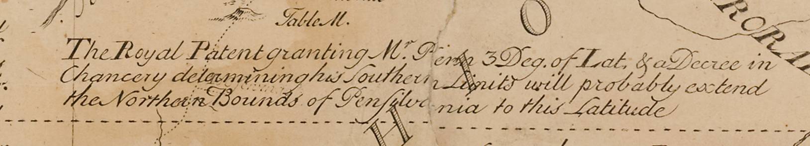
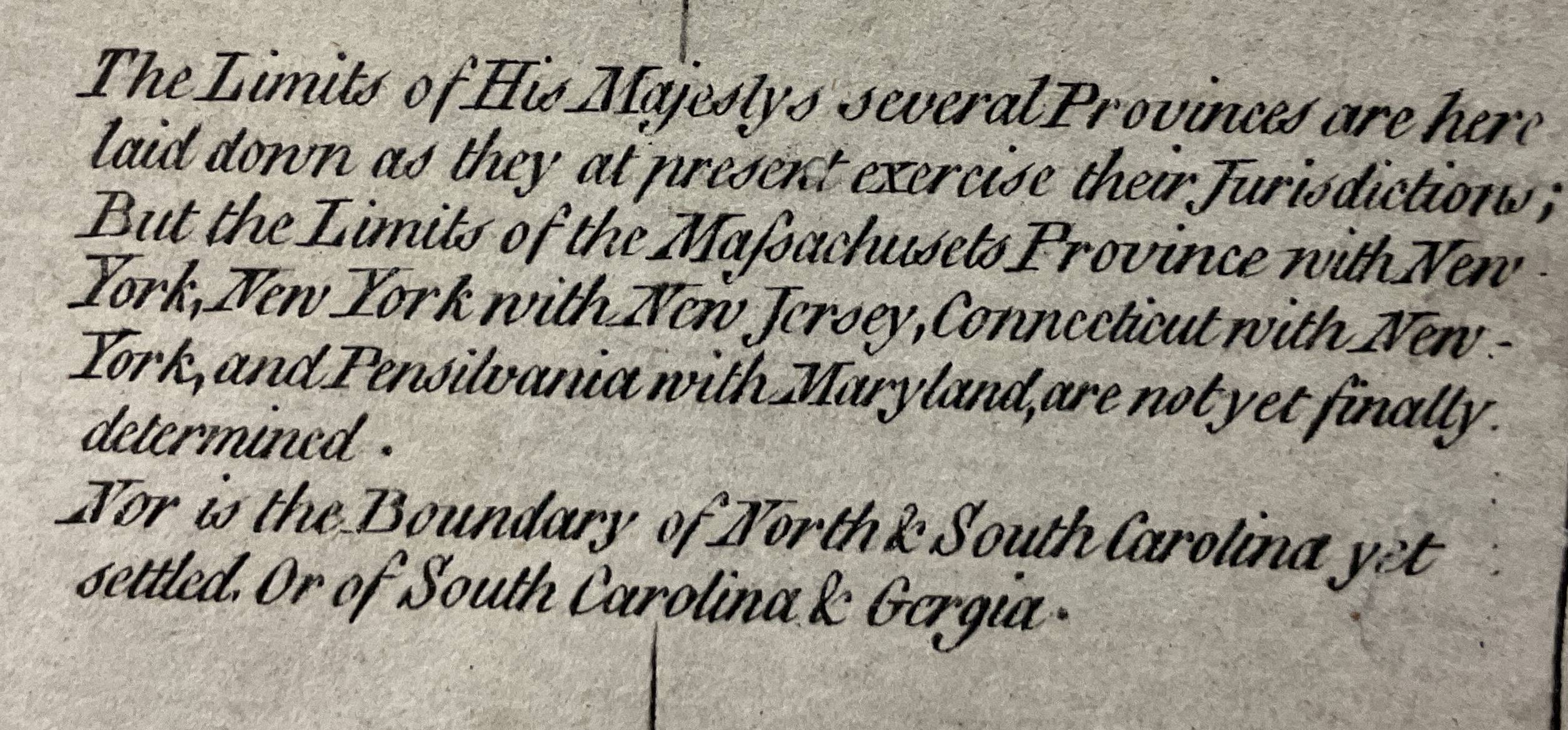
The Royal Charters that created colonies out of undefined expanses of territory that were claimed on the basis of discovery included expansive and unbounded descriptions of colonial space. The second Charter of Virginia (1609) stipulated that the colony included,
all those Lands, Countries, and Territories, situate, lying, and being in that Part of America, called Virginia, from the Point of Land, called Cape or Point Comfort, all along the Sea Coast to the Northward, two hundred miles, and from the said Point of Cape Comfort, all along the Sea Coast to the Southward, two hundred Miles, and all that Space and Circuit of Land, lying from the Sea Coast of the Precinct aforesaid, up into the Land throughout from Sea to Sea, West and Northwest;
The ‘sea to sea’ clause was later interpreted that Virginia extended to the South Sea, an imagined body of water that colonial officials were still searching for in the 1670s. The Charter of Massachusetts Bay (1629) was similarly extensive, consisting of:
that Parte of America, lyeing and being in Bredth, from Forty Degrees of Northerly Latitude from the Equinoctiall Lyne, to forty eight Degrees Of the saide Northerly Latitude inclusively, and in Length, of and within all the Breadth aforesaid, throughout the Maine Landes from Sea to Sea;
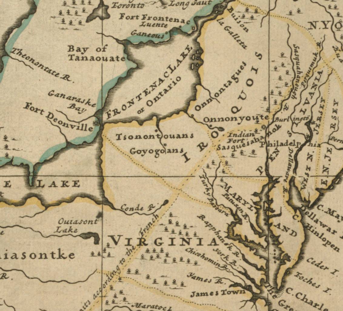
As settlement expanded into the western reaches of Pennsylvania and Virginia, maps began to employ a wider lens, placing colonies in a Continental perspective. A number of these maps were produced by Europeans, who apparently saw North America as a space of competing empires arrayed across vast expanses of territory. The London-based German cartographer Herman Moll arranged the continent as a division of French and Indigenous territory, with tentative dotted colonial boundaries and lines to indicate disputed territorial claims. The Dutch illustrator Michael Burghers’ map of 1738 showed the ‘Principal Divisions’ of North America, including Britain’s Atlantic colonies and the massive Spanish claims in the Southwest. His colonial boundaries surge westward and terminate only when they encounter rivers or lakes. Geographical details are incorrect: the Appalachians run east-west, while the northwest is entirely empty, except for the map’s large label. The most accurate elements of the map concern the relative positions and homelands of Indigenous nations, which occupy the largest expanses of land.
The most detailed maps focussed on areas where the British were directly engaged in diplomacy and trade with Indigenous nations. Lewis Evans marked territorial divisions based on royal patents and charters and included blocks of text that took the form of remarks on the landscape that acknowledged what spaces had been visited and surveyed and which were still unknown. Knowledge of the interior spaces of the Northeast is based on a combination of land surveys, diplomatic travel, and the inter-cultural exchange of information.
William Herbert’s ‘new’ and ‘accurate’ map of an English ‘empire’ (1755) indicated Britain’s ‘rightful claim’ to territory based on ‘Charters, and the formal surrender of their Indian friends’. Herbert was a member of the anti-Gallican society in London, a dining club for men (only) who were united in their suspicion of the global imperial policies of France. He presented French territorial claims as belligerent rather than as peaceful agricultural or urban pursuits, achieved by fortification as opposed to the ‘legal’ mechanisms of charter and treaties. The map seeks to draw the British and Indigenous worlds closer together but running in parallel tracks as suggested by two row wampum belts. English spaces are defined by dotted and coloured lines, while Indigenous spaces are presented as a broad cluster of historically occupied villages.

The charter borders of colonies are shown at scale on John Mitchell’s map, where they run west to the Mississippi River. The view of the map is continental, but its principal divisions are the natural features of lakes and rivers. Where other maps showed the Appalachians in high relief, Mitchell made mountains less prominent than rivers. For a map that is apparently concerned with providing a detailed illustration of British and French dominions, Mitchell’s has surprisingly few artificial borders or boundaries. Instead, the bounds of the British domains are defined by blocks of territory ceded by Indigenous nations to the Crown.
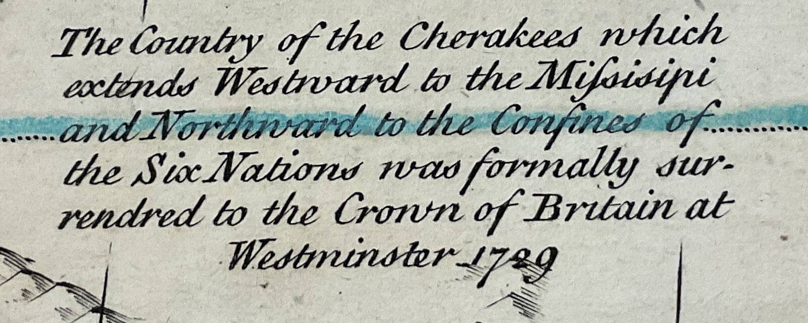
The Royal Proclamation of 1763 created the largest border in North America. In order to consolidate a vast new territory ‘secured to our Crown by the late definitive treaty of peace’, it created four new governments in lands surrendered by the French Crown at the Treaty of Paris (1763). The Proclamation established a line running from Maine to Florida and ordered that Indigenous nations should not be ‘disturbed in the possession of such parts of our dominions and territories . . . are reserved to them’. The line established by the Proclamation limited the further westward settlement of colonies and ordered that settlers on the western side of the line ‘remove themselves from such settlements’.
A letter in the St James Chronicle (1764) used strongly racialised language to condemn the Proclamation for having ‘given up all the Country, West of the Alleganey Mountains, to the Savages’. For settlers, the Crown’s policy gave land and sovereign recognition to the historic enemies of the colonies. Where the Crown, based on its treaties, recognised the sovereignty and territorial possession of Indigenous nations, colonial officials looked back to instances of violence that consumed dozens of colonial towns in the seventeenth century. For them, diplomacy achieved nothing, since Indigenous polities acted ‘contrary to the Faith of Treaties, subsisting between them and the Crown, invaded our Colonies East of the Alleganey Mountains, laying waste all the Country before them with Fire and Sword’.
Later maps used European treaties to produce a more ‘accurate’ depiction of the British empire, placing it within a Continental view, alongside the territories of Spain – the Crown’s last European rival for imperial supremacy. Emanuel Bowen’s map of 1772 included the complete text of six of twenty-seven articles from the Treaty of Paris, including one that described all British territorial claims to the east of the Mississippi River. But while the Treaty was definitive in the sense that it established the size and limits of Britain’s vast new imperial claims, within this enlarged space the borders of colonies in relation to one another were not complete, and Bowen’s representation of tentative borders stopped far short of the Mississippi River, terminating along the Proclamation Line of 1763. This was the west.
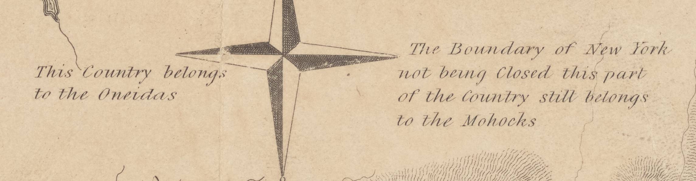
Where colonies sat near Indigenous nations, the lack of borders meant that there was no hard division between, for example, the territories of the Haudenosaunee and those of New York. Guy Johnson’s map of the Six Nations takes the Mohawk River as a natural border.: ‘The boundary of New York not being Closed this part of the country still belongs to the Mohawks’.
The transition between British empire and the American territorial republic was formalised by the second Treaty of Paris (1783). The United States’ new national borders were mapped in the same year by John Cary who, like Bowen, reproduced articles of the Treaty on a map with few and faint borders between states. The text of these articles did the same work as early colonial charters, in that they described – this time on a continental scale – the agreed boundaries of the United States, ‘that all disputes which might arise in future, on the subject of the boundaries of the said UNITED STATES may be prevented’. Thicker and apparently more definite state borders appeared on Abel Buell’s ‘new and accurate’ map of the United States (1784), the first produced in the new republic. Yet Buell’s map erased New York entirely while expanding his home state of Connecticut, which reached into the Northwest Territory. Buell’s states behaved exactly like their colonial ancestors, stretching their territorial claims from sea to sea.
The names and location of Indigenous nations appeared on all these maps. In its early years, the United States sought to carry on diplomatic relations in the manner of the British. Following the formalisation of the boundary set out in the Treaty of Paris (1783), the United States employed the Treaty of Fort Stanwix to push further west into the homelands and former village worlds of the Haudenosaunee. The Congress informed them that
all the Tribes and Nations of Indians who live to the Southward and Westward of the line agreed on . . . must no longer look to the King beyond the water, but they must now look to the Great Council, the Congress of the United States at Philadelphia.
This meant that the United States would relate to Indigenous nations as independent sovereigns. Occupying less than a third of the Continent, and surrounded by the imperial claims of Britain and Spain, and facing an interior controlled by wide-ranging equestrian societies of the trans-Mississippian West, American politicians were fully aware of the spatial complexities that would influence the future development of the state. As Henry Knox, the Secretary of War, put in in 1791, ‘The United States have come into existence, as a nation, embarrassed with a frontier of immense extent, which is attended with all the peculiar circumstances’.
Explore
Customize your search using the filters below. Choose the map images or feature icons to enable the filters you require.